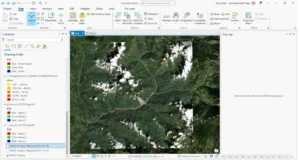
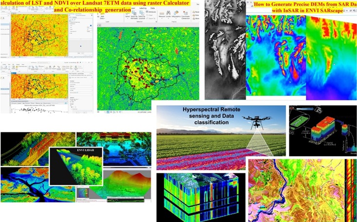
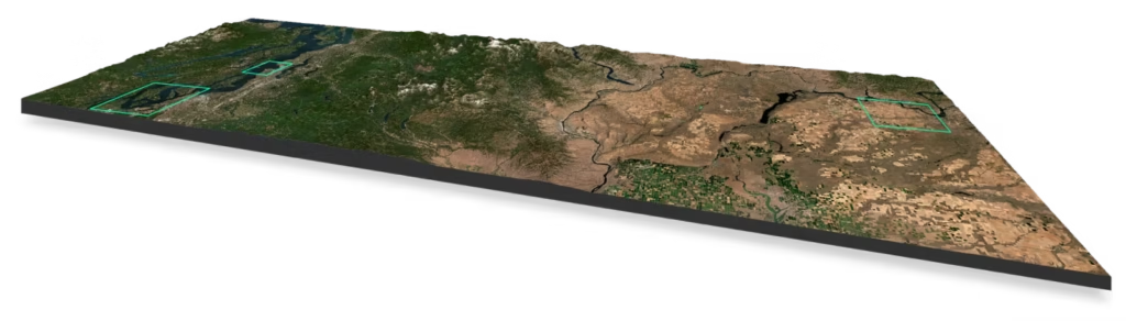
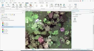
Site Logo

Space Remote Sensing & GIS

Forest Fire monitoring

Giving consultancy advice on Forest Fire assessment

Flood Monitoring

Giving consultancy advice for Flood analysis

Training on Advance Remote sensing

Training on SAR, Hyperspectral and thermal and Lidar data processing

Training on Advance GIS

Advance GIS spatial modeling and web GIS

Harness the power of multidimensional Earth insights to look broader with daily monitoring, closer with high resolution tasking, and deeper with derived data.

Look broader.

Look closer.

Look deeper.

Program Provide

School Programs

Space Remote Sensing & GIS offers a range of meticulously curated, school-based educational programs in Astronomy, Space Science, and STEM (Robotics, Drones & AI) to promote the development of 21st-century skills in students. Our programs are the culmination of years of research and are tailored to different age groups following the National Education Policy. At Space Technology and Education Pvt. Ltd., we are committed to providing high-quality educational programs that inspire the next generation of scientists and innovators. Our team of experts is dedicated to ensuring that our programs are engaging, informative, and promote a deep understanding of the fascinating world of science and technology.

The organization is committed to nurturing the next generation of space science students by providing unparalleled educational standards. Our passion for inspiring and mentoring students is evident in their unwavering dedication to cultivating young minds and fostering a love for space science.

Rural Programs

Space Remote Sensing & GIS offers a range of meticulously curated, school-based educational programs in Astronomy, Space Science, and STEM (Robotics, Drones & AI) to promote the development of 21st-century skills in students. Our programs are the culmination of years of research and are tailored to different age groups following the National Education Policy. At Space Technology and Education Pvt. Ltd., we are committed to providing high-quality educational programs that inspire the next generation of scientists and innovators. Our team of experts is dedicated to ensuring that our programs are engaging, informative, and promote a deep understanding of the fascinating world of science and technology.

The organization is committed to nurturing the next generation of space science students by providing unparalleled educational standards. Our passion for inspiring and mentoring students is evident in their unwavering dedication to cultivating young minds and fostering a love for space science.

Workshop

Space Remote Sensing & GIS offers a range of meticulously curated, school-based educational programs in Astronomy, Space Science, and STEM (Robotics, Drones & AI) to promote the development of 21st-century skills in students. Our programs are the culmination of years of research and are tailored to different age groups following the National Education Policy. At Space Technology and Education Pvt. Ltd., we are committed to providing high-quality educational programs that inspire the next generation of scientists and innovators. Our team of experts is dedicated to ensuring that our programs are engaging, informative, and promote a deep understanding of the fascinating world of science and technology.

The organization is committed to nurturing the next generation of space science students by providing unparalleled educational standards. Our passion for inspiring and mentoring students is evident in their unwavering dedication to cultivating young minds and fostering a love for space science.

Online Lectures

Space Remote Sensing & GIS offers a range of meticulously curated, school-based educational programs in Astronomy, Space Science, and STEM (Robotics, Drones & AI) to promote the development of 21st-century skills in students. Our programs are the culmination of years of research and are tailored to different age groups following the National Education Policy. At Space Technology and Education Pvt. Ltd., we are committed to providing high-quality educational programs that inspire the next generation of scientists and innovators. Our team of experts is dedicated to ensuring that our programs are engaging, informative, and promote a deep understanding of the fascinating world of science and technology.

The organization is committed to nurturing the next generation of space science students by providing unparalleled educational standards. Our passion for inspiring and mentoring students is evident in their unwavering dedication to cultivating young minds and fostering a love for space science.

Podcast

Space Remote Sensing & GIS offers a range of meticulously curated, school-based educational programs in Astronomy, Space Science, and STEM (Robotics, Drones & AI) to promote the development of 21st-century skills in students. Our programs are the culmination of years of research and are tailored to different age groups following the National Education Policy. At Space Technology and Education Pvt. Ltd., we are committed to providing high-quality educational programs that inspire the next generation of scientists and innovators. Our team of experts is dedicated to ensuring that our programs are engaging, informative, and promote a deep understanding of the fascinating world of science and technology.

The organization is committed to nurturing the next generation of space science students by providing unparalleled educational standards. Our passion for inspiring and mentoring students is evident in their unwavering dedication to cultivating young minds and fostering a love for space science.

Conference

Learn With Our Video

Organizations across industries and geographies work with Planet to gain a global, dynamic perspective about their most pressing operational challenges.

Earth Gallery

Meet Our Mentor

Partners & Affiliations

Achievements

Research Publications

Journals

  • Chakraborty, S.D., Patil, T.C., et al. (2013). Impacts Of Sujala On Land Use /Land Cover Transformation And Socio-Economic Changes In Jonnikeri Watershed. Asian Academic Research Journal of Multidisciplinary, 1(9), 68-78.
  • Chakraborty, S.D., Kant, Y., Mitra, D. (2015). Assessment of Land Surface Temperature and Heat Fluxes over Delhi Using Remote Sensing Data. Journal of Environmental Management, 148, 143-152.
  • Verma, P., Chakraborty, S.D. (2014). Study of Spatial Variability of Ground Water Depth and Quality in Haridwar District. IJAST, 2(4), 570-580.

Book Chapters

  • Chakraborty, S.D., Kant, Y., Reddy, K.M., Rao, P.J. (2022). Investigation of Land Use and Landcover Changes and Its Relationship with Land Surface Temperature and Ground Water Temperature Over Bangalore City. In Remote Sensing and GIS for Policy Decision Support, 219–233.
  • Das, S., Ganguly, K., Mitran, T., Chakraborty, S.D. (2022). Applications of Geospatial Technologies Toward Achieving Sustainable Development Goals. In Application of Remote Sensing and GIS in Natural Resources and Built Infrastructure Management, Springer.
  • Chakraborty, S.D., Patil, T.C., & Manjula, B.V., Ranganath, B.K. Impact Evaluation of Jonnikere Watershed, Aurad Taluk, Bidar District, Karnataka.
  • Chakraborty, S.D., Patil, T.C., & Manjula, B.V., Ranganath, B.K. Impact Evaluation of Uddanur-Belthur Watershed, Kollegal Taluk, Chamrajanagar District, Karnataka.
  • Chakraborty, S.D., Patil, T.C., & Manjula, B.V., Ranganath, B.K. Impact Evaluation of Keralli Watershed, Shirahatti Taluk, Gadag District, Karnataka.
  • Chakraborty, S.D., Patil, T.C., & Manjula, B.V., Ranganath, B.K. Impact Evaluation of Kyatanakeri Watershed, Indi Taluka, Bijapur District, Karnataka.

Young Scientist Aspirant Fellowship

Karlsruhe Institute of Technology, Germany (2015)

Pat on Back Award

ESRI India (Q2 2021, Q3 2021)

Technovator Award

ESRI India (Q4 2022)

Valuable Player Award

ESRI India (Q2 2024)

YouTube Videos

Blog

Testimonials

Testimonial #1

Review Text

Testimonial #2

Review Text

Testimonial #3

Review Text

Scroll to Top